Kerala's weather has felt wrong for months. October nights that should be cooling down are staying warm. Daytime temperatures in several districts have crossed 35°C, with departures of 3 to 5°C above normal. The southwest monsoon ended with a national rainfall deficit of roughly 12.6%, and Kerala's own deficit ran between 26% and 28% below normal. If you have been sleeping badly or noticed your AC running longer than usual, you are not imagining things.
The cause has a name: a Super El Niño, and by the numbers it is shaping up to be one of the most powerful climate events since systematic records began in 1950.
For anyone who depends on air conditioning or refrigeration in Kerala, whether at home, in a commercial building, a bank branch, a restaurant, or a cold storage facility, the next six to eight months demand preparation, not reaction. This article lays out the data behind that statement, what it means district by district, and what you can do about it.
What is El Niño, and why are they calling this one "Super"?
El Niño is a recurring climate pattern. Every 2 to 7 years, sea-surface temperatures (SSTs) in the central and eastern tropical Pacific Ocean warm abnormally. This warming disrupts atmospheric circulation across the globe, shifting rainfall patterns, intensifying heat in some regions, and causing droughts in others. The phenomenon is measured by tracking SST anomalies in a specific patch of the Pacific called the Niño 3.4 region (the strip of ocean between 5°N to 5°S latitude, and 120°W to 170°W longitude).
A standard El Niño is declared when the Niño 3.4 SST anomaly exceeds +0.5°C above the long-term average for five consecutive overlapping three-month periods. This is measured using the Oceanic Niño Index (ONI).
NOAA classifies El Niño events by intensity:
| Classification | Niño 3.4 anomaly |
|---|---|
| Weak | +0.5°C to +0.9°C |
| Moderate | +1.0°C to +1.4°C |
| Strong | +1.5°C to +1.9°C |
| Very Strong / "Super" | +2.0°C and above |
The informal label "Super El Niño" is used when the anomaly exceeds +2.0°C in a sustained manner. NASA and climate researchers often use a stricter threshold of +2.5°C to distinguish the most destructive events in recorded history.
Only four El Niño events since 1950 have earned the "Super" label: 1972-73, 1982-83, 1997-98, and 2015-16. The 1997-98 event peaked past +2.5°C and caused catastrophic floods, droughts, famines and forest fires globally. The last event in 2023 resulted in 34% rainfall deficit in Kerala, with cases of both simultaneous agricultural droughts and severe localised flash flooding.
The 2026-27 event is tracking to join that list, and possibly surpass it.
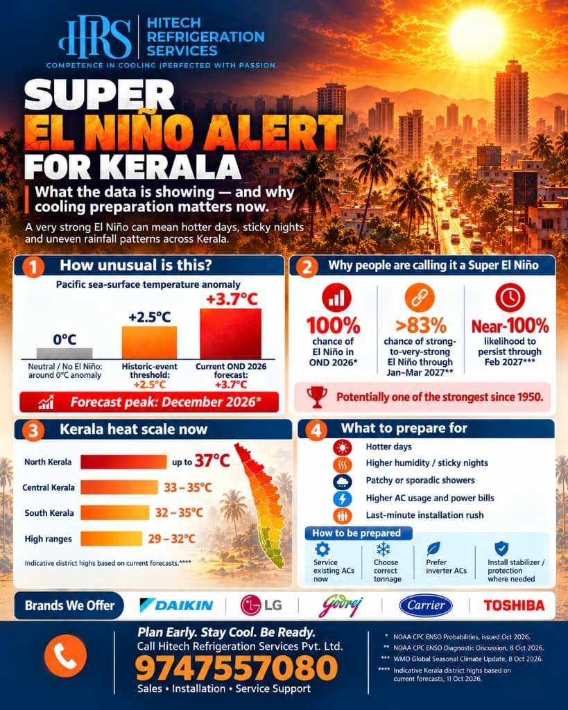
The numbers: NOAA CPC and WMO forecasts for OND 2026
The NOAA Climate Prediction Center (CPC) issued its October 2026 ENSO Diagnostic Discussion with stark numbers:
- Current Niño 3.4 SST anomaly: above +3.0°C, with localised spikes even higher in the eastern equatorial Pacific
- 83% probability that the October-November-December (OND) 2026 peak season will reach or exceed a +2.5°C anomaly
- Near-100% certainty that strong-to-very-strong El Niño conditions will persist through January to March 2027
- Transition to ENSO-neutral is not anticipated before late spring or early summer 2027
The World Meteorological Organization's (WMO) Global Seasonal Climate Update for October 2026 adds further detail:
- Multi-model ensemble forecasts from 13 global forecasting centres project Niño 3.4 anomalies reaching approximately +3.7°C during OND 2026
- The event is expected to reach peak intensity around December 2026
- A concurrent positive Indian Ocean Dipole (IOD) and above-normal SSTs across the tropical Atlantic are compounding the effect
- Above-normal land surface temperatures are expected across virtually the entire globe through Q1 2027
To put that +3.7°C projection in context: the 1997-98 Super El Niño, the one that reshaped global climate policy and disaster preparedness, peaked at around +2.5°C to +2.6°C. If the WMO ensemble forecast holds, this event would significantly exceed any El Niño in the modern record.
How this translates to Kerala: what is already happening
The Super El Niño does not heat Kerala directly. It works by disrupting atmospheric circulation: weakening moisture-laden winds, suppressing normal convective cloud cover, and enhancing high-pressure ridges over the southern peninsula. The downstream effects are already measurable.
Hotter days, across more districts. Multiple districts have recorded temperatures 3 to 5°C above their seasonal average. Palakkad, Thrissur, and parts of Ernakulam have consistently breached 35°C during periods that are normally moderate.
Warmer, stickier nights. Night temperatures have been running 2 to 3°C above normal. This is the less obvious but more punishing effect. When outdoor temperatures do not drop enough after sunset, buildings retain heat. The AC has to work harder and longer to bring indoor temperatures down. Sleep quality drops. Energy consumption rises. This is the pattern that makes people say "it's not even summer yet and we're already running the AC all night."
Patchy, sporadic rainfall instead of uniform coverage. Rather than the steady, widespread rain patterns Kerala normally sees during the northeast monsoon, the current season is producing scattered, uneven showers. Some areas get a downpour; neighbouring taluks stay dry and warm. The gaps between rain events are longer, and the dry spells are hotter than usual. This means fewer natural cooling cycles and less reliable respite between warm periods.
Higher humidity with less relief. The combination of warmer seas around the Indian coastline and altered wind patterns produces sticky, oppressive humidity even when it is not raining. The air feels heavy. Rooms feel stuffy and damp. Fans circulate warm, moist air rather than providing comfort. This is the exact condition where air conditioning shifts from convenience to necessity, and where AC units face the hardest operating conditions: high ambient temperature combined with high moisture load.
What to expect district by district: projected summer 2027 highs
While official high-resolution IMD forecasts for summer 2027 will be released closer to the season, long-term trends mapped against past severe El Niño years (1997-98, 2015-16, and 2024's hot spell) give a strong indication of what each district should brace for:
| District | Typical April-May peak | Projected El Niño peak | Key risk |
|---|---|---|---|
| Palakkad | 37-38°C | 40-41.5°C | Palakkad Gap funnels dry heat from Tamil Nadu; multiple consecutive heatwave days (IMD criteria: 40°C+ with +4.5°C departure from normal) are highly likely |
| Thrissur | 35-36°C | 38-39.5°C | Inland stations like Vellanikkara historically track close behind Palakkad |
| Kollam | 34-35°C | 38-39.5°C | Interior station Punalur is among the state's hottest midland locations |
| Kottayam | 34-35°C | 37-38°C | Afternoon showers that normally moderate heat may be delayed or absent |
| Ernakulam | 33-34°C | 35-37°C | Thermometer reads lower, but high relative humidity pushes real-feel / heat-index temperatures far higher; persistent discomfort despite moderate readings |
| Kozhikode | 33-34°C | 35-37°C | Coastal humidity + suppressed sea breeze during El Niño periods |
| Thiruvananthapuram | 33-34°C | 35-37°C | High UV indices (levels 6 to 9) compound heat stress |
| Alappuzha | 33-34°C | 35-36°C | Low-lying coastal geography traps humid air; dehumidification demand spikes |
| Idukki / Wayanad | 28-30°C | 30-33°C | Normally cooler hill stations will see unusual warmth; forest fire risk increases due to drier conditions |
The consistent pattern: raw thermometer temperatures will be 2 to 4°C above normal, but the combination of high relative humidity and sustained heat through the night will make the experienced discomfort far worse than the number on the thermometer suggests.
Kerala's electricity supply problem: already strained before summer arrives
This is where the Super El Niño compounds into a systemic problem. Kerala generates only about 20% to 25% of its total electricity requirement internally, relying heavily on hydroelectric power. The rest comes from Central Generating Stations, long-term power purchase agreements, and power exchanges.
The 2026 monsoon was catastrophic for hydel generation:
- Southwest monsoon rainfall deficit across Kerala ran 26% to 28% below normal
- Reservoir storage at key hydel projects dropped to roughly 21% at the start of the monsoon crunch in June and recovered to only about 61% by end-September, significantly lower than previous years
- Daily power demand routinely crossed 5,000 to 5,400 MW, well above the historical 3,600-3,700 MW baseline for the period
- KSEB was forced to implement rolling load-shedding (15 to 45-minute power cuts) during late evening and night hours to prevent grid failure
- The state had to secure an emergency supply agreement of 600 to 900 MW from Himachal Pradesh to stabilise the grid heading into October
The situation heading into summer 2027 is structurally worse than recent years. Hydel reserves are lower. National coal inventories face strain because northern states are simultaneously dealing with their own heat. The Day-Ahead and Real-Time power markets are expected to be tight and expensive. And residential + commercial cooling demand will be higher than anything the grid has handled before, because people who were already running ACs at unusual hours will be running them even more.
What this means for you: expect higher electricity bills, more frequent voltage fluctuations, and possible power cuts during peak evening and night hours. Your AC will need to restart after outages (hard-starting is particularly stressful for older compressors), and inconsistent supply shortens the life of electrical components.
What the everyday consumer should prepare for
The Super El Niño is not an abstract weather statistic. It translates into specific, tangible changes to daily life in Kerala over the next six to eight months:
Your AC will run longer and cost more. Systems designed for four or five months of heavy use (April through August) are now facing six or seven months of near-continuous operation. The compressor runs longer cycles, consumes more energy per cycle due to higher ambient temperatures, and the electricity bill climbs accordingly. A home that normally spent ₹2,500-3,000/month on electricity during summer may see that cross ₹4,000-5,000 if the AC is running through the night.
Nights will be uncomfortably warm. Night temperatures 2 to 3°C above normal do not sound dramatic, but they make the difference between sleeping with a fan and needing the AC all night. Buildings absorb heat during the day and release it slowly. When the outdoor temperature at midnight is still 28 or 29°C instead of the usual 25 or 26°C, the room never cools down on its own.
Humidity will be relentless. Even outside the monsoon months, the warmer Arabian Sea surface will push moist air inland. Rooms will feel clammy. Clothes dried indoors will take longer. Wardrobes and storage areas will smell damp. Mould and mildew will appear in bathrooms and behind furniture. Your AC will need to handle dehumidification as much as cooling, and a system with a dirty evaporator coil or a blocked drain line will not do it well.
The service rush will be worse than any previous year. Every year, the AC service industry in Kerala faces a March-to-May crunch. This year, with sustained heat starting earlier and more systems under stress, the rush will begin sooner and last longer. Technicians, spare parts, gas refills, and installation slots will all be scarce. If you wait until you feel the heat to call for service, you may wait days or weeks.
New AC installation will be backlogged. If you are planning to buy a new AC, the window to get it installed without a long wait closes rapidly after January. Dealers sell out of popular models. Installation crews are overbooked. Pricing moves up. Buying and getting installed in November or December, before demand spikes, means better availability, often better pricing, and guaranteed technician time for proper installation.
The case for solar: offset the bill before it hits
If your electricity bill is already climbing and you expect it to get worse, there is a structural solution worth considering now rather than in the middle of summer: rooftop solar with KSEB net metering.
The economics are straightforward for Kerala homes:
- A 3 kW rooftop solar system generates roughly 300 to 350 units per month
- Kerala's residential tariff crosses ₹6.40 to ₹8.50+ per unit at higher consumption slabs; the slabs that AC-heavy households consistently land in
- Estimated annual savings: ₹35,000 to ₹40,000 per year
- Under the PM Surya Ghar: Muft Bijli Yojana scheme, residential consumers can access subsidies of ₹30,000/kW for the first 2 kW and ₹18,000 for the 3rd kW, up to a maximum of ₹78,000
- Monthly bills that previously hovered around ₹3,000-5,000 (inflated by AC usage) can be brought down close to the baseline fixed charges
During the day, solar panels power your AC directly, reducing grid intake. Surplus units are exported to the KSEB grid through a bidirectional net meter and credited against the power you draw at night when the AC runs after sunset. The mismatch between daytime generation and nighttime AC consumption is exactly what net metering is designed to handle.
The timing argument is strong: solar installations take 4 to 8 weeks from order to commissioning. If you start the process now, the system can be operational before the worst of the summer billing arrives. If you wait until April and the bill has already spiked, you are paying peak rates for months while the installation queue stretches out.
Solar does not eliminate the need for a reliable, well-maintained AC. But it dramatically reduces the financial pain of running one for extended hours in a Super El Niño year.
Why existing AC systems are at risk
Most AC installations in Kerala homes and offices were sized and maintained for a "normal" climate pattern: a hot April and May, relief from June through September, and gradual cooling from October. The Super El Niño breaks that pattern.
Compressor stress increases. A compressor that runs 14 hours a day instead of 8 draws more energy and accumulates wear faster. Refrigerant charge that was borderline adequate at normal loads becomes insufficient when the system never cycles off. Condenser coils clogged with dust and pollutants from a drier-than-usual monsoon cannot reject heat efficiently, forcing the compressor to work against higher pressures.
Drainage problems multiply. Higher humidity combined with extended run hours means more condensate. Drain lines that were passable become blocked. Water leaks into false ceilings, walls, or electrical panels.
Electrical components overheat. Capacitors, contactors, and wiring rated for intermittent cycling degrade faster under sustained load. Power fluctuations during peak grid demand compound the stress.
Filters and coils foul faster. A drier, dustier transition season means more particulate matter entering indoor units. Filter clogging reduces airflow, increases run time, and raises the electricity bill, often before anyone notices the room is less comfortable.
None of these are catastrophic failures on their own. But stacked together across a six-month stretch, they turn a reliable AC into a system that is underperforming, overcooking the electricity bill, or heading toward a breakdown at the worst possible moment, deep into summer when every HVAC technician in the state is booked out for days.
What to do now: the preparation checklist
For homeowners
Get your AC serviced before the rush. Not in March when the heat is already unbearable and every service company has a two-week backlog. Now, during October or November, while the northeast monsoon provides a brief window of milder weather and technician availability. A proper pre-summer service includes checking refrigerant pressure, cleaning both indoor and outdoor coils, flushing the drain line, testing capacitors and electrical connections, and verifying thermostat accuracy. A quick filter rinse misses most of the problems that cause high bills and breakdowns.
Consider an AMC if you do not have one. An Annual Maintenance Contract locks in scheduled visits and priority response. When every AC in the district needs emergency attention in April, AMC customers get served first. For a Super El Niño year, this is insurance against a predictable bottleneck.
Check your stabiliser and electrical setup. Grid instability during peak demand is a real risk. If your AC is running without a stabiliser, or on a stabiliser rated lower than the unit's requirement, voltage spikes and dips can damage the compressor. Inverter ACs handle voltage fluctuation better than fixed-speed units, but even inverters have limits.
Set the thermostat to 24-26°C. Every degree below that increases runtime and energy consumption without making the room meaningfully more comfortable. If you are setting it to 18°C and throwing a blanket on, you are paying to heat and cool at the same time.
Seal the room. Air leaks under doors, through gaps around window ACs, and into unconditioned corridors force the AC to cool air that is constantly being replaced. Weatherstripping and door closers are inexpensive and often deliver a larger bill reduction than upgrading the AC itself.
Explore rooftop solar before summer. As outlined above, a 3 kW system with KSEB net metering can offset ₹35,000-40,000/year in electricity costs. The PM Surya Ghar subsidy brings the upfront cost down significantly. Start the process now so the system is live before peak billing months.
For businesses and facility managers
Audit your cooling load against the new reality. A building that was comfortable with its current HVAC capacity during normal summers may struggle when ambient temperatures run 3 to 5°C above historical norms. A professional energy audit identifies where the system is losing capacity: underperforming equipment, duct leaks, insufficient insulation, or operational schedules that do not match actual occupancy.
Schedule preventive maintenance before Q1 2027. For multi-unit installations, VRV/VRF systems, ducted units, and packaged ACs, lead times for parts and service are already stretching. OEM-certified technicians who can work on Daikin, Carrier, and LG commercial equipment are a limited resource. Booking preventive maintenance now, rather than reacting to failures in March, is the difference between a scheduled two-hour visit and a three-day emergency scramble.
Cold chain operators: stress-test your reefer and cold room systems. If ambient temperatures during transport and storage run significantly higher than your refrigeration was designed for, product temperatures will drift. For pharmaceuticals, dairy, poultry, and seafood, that drift means spoilage or compliance failure.
Plan for power disruptions. Diesel generator capacity, UPS systems for critical cooling loads, and demand-management protocols (staggering startup times across multiple AC units to avoid inrush current spikes) are worth reviewing before the grid is under maximum stress.
The timeline: what to expect through mid-2027
| Period | What happens | What to do |
|---|---|---|
| Oct-Dec 2026 | Northeast monsoon provides partial relief. Night temperatures remain elevated. El Niño peaks around December (+3.7°C projected). | This is the preparation window. Service ACs, book AMCs, order solar, buy replacement units. |
| Jan-Feb 2027 | Summer onset may arrive 4 to 6 weeks early. Daytime temperatures begin climbing before the usual March ramp. Pre-monsoon showers will be delayed or erratic. | Unprepared systems start showing strain. Service backlogs begin building. |
| Mar-May 2027 | Peak heat. Palakkad projected to breach 40°C on multiple days. Power demand peaks. Technician availability drops to its lowest. Electricity bills spike. Cold chain compliance hardest to maintain. | Reactive service calls face days-to-weeks wait times. Emergency compressor replacements and gas refills are expensive and scarce. |
| Jun 2027 onward | If El Niño weakens on schedule (ENSO-neutral by late spring), monsoon arrival brings gradual relief. But a delayed or weak monsoon, which El Niño years frequently produce, would extend the strain. | Monitor NOAA/IMD updates for monsoon onset timing. |
If you are buying a new AC
If your current AC is old, undersized, or inefficient, replacing it before the Super El Niño summer may make more financial sense than nursing it through another year. A modern inverter AC with a higher BEE star rating will draw significantly less power under sustained load than an older fixed-speed unit.
AC prices and availability follow seasonal demand. Units sell faster and at higher prices from February onward. Buying in November or December often means better availability and, in some cases, better pricing. Proper installation matters as much as the unit itself. A poorly installed AC, with incorrect pipe lengths, bad vacuum, or insufficient drainage slope, will underperform from day one. HRS provides manufacturer-certified installation with warranty-compliant procedures.
The bottom line
The Super El Niño is not a forecast anymore. It is here, confirmed by NOAA, WMO, and IMD, with Niño 3.4 anomalies already past +3.0°C and projected to reach +3.7°C by December. It will persist through at least March 2027. Kerala's cooling infrastructure, from individual split ACs in bedrooms to large commercial HVAC plants and cold chain systems, is about to face a workload it was not designed for, on a power grid that is already under strain from the weakest monsoon season in recent years.
The math favours preparation. A full AC service costs a fraction of an emergency compressor replacement. An AMC costs less than a week of downtime at a commercial facility. An energy audit pays for itself in reduced electricity bills within months. A rooftop solar system starts paying back from the first month of operation.
If your cooling systems have not been serviced recently, or if you are unsure whether your setup can handle an extended, abnormally hot season, get in touch with HRS. We have been keeping Kerala cool through every climate cycle since 1999. This one will not be different, but it will reward the prepared.